
Features Hawk Map GPS-GIS
GPS and coordinate systems helper especially for military personnel.It is also a complete helper for airsoft, mountaineering, trekking and hiking, cross running, scouting, hunting, fishing, geocaching, off-road navigation and all other outdoor activities and sports.With satellite navigation systems such as GPS, GALILEO and GLONASS (GNSS) supported by your device and your sensors, you can see your most accurate position on different map layers.⭐⭐Features⭐⭐
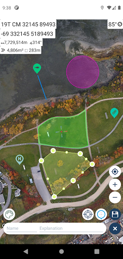
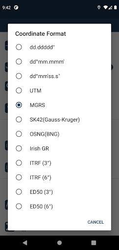
👉 Coordinate Indicator, finder and converter Format options: - D°MS" (WGS84) - Latitude/Longitude (WGS84) - UTM (WGS84/NAD83), - MGRS / U.S.
National Grid (USNG) (WGS84/NAD83) - SK42(Gauss Kruger) - British National Grid(BNG-OSNG) - Irish Grid Reference - ED50 (6°-3°) - ITRF (6°-3°)
👉 You can make colored markings on the map.
Markers,Polygons,Polylines,Circles
👉 Area & Distance measurement Distance unit options: m , ft , mi , yd , nmi Area unit options: m² , ha , ft², yd², mi²
👉 Elevation information
👉 Compass Angular unit options: Degrees ,NATO mil, Warsaw Mil, Grad
👉 Map style options: (Road,Terrain,Satellite,Night Mode,Hybrid)
👉 KML viewer.
(Export and import KML layers).
👉 GPS track recorder.
Camera Features
Advanced camera features with editing capabilities.
Fitness Tracking
Track your workouts and monitor your health metrics.
Travel Features
Plan and manage your travels with ease.
See the Hawk Map GPS-GIS in Action

Get the App Today
Available for Android 8.0 and above